

-
Welcome to Tacoma World!
You are currently viewing as a guest! To get full-access, you need to register for a FREE account.
As a registered member, you’ll be able to:- Participate in all Tacoma discussion topics
- Communicate privately with other Tacoma owners from around the world
- Post your own photos in our Members Gallery
- Access all special features of the site
 Boise, Idaho trails
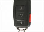 Portland Auto Locksmith Recommendations
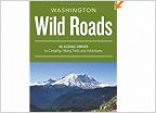 Washington State "Wild Roads" book
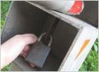 Anyone else get locked inside a DNR gate?
 ISO: Seattle-Tacoma Area Techstream for Hire
 Help on leaf install
Lost Corner Exploration
Discussion in 'North West' started by Smar969905, Mar 8, 2014.
Page 16 of 32
Page 16 of 32
Products Discussed in


