

-
Welcome to Tacoma World!
You are currently viewing as a guest! To get full-access, you need to register for a FREE account.
As a registered member, you’ll be able to:- Participate in all Tacoma discussion topics
- Communicate privately with other Tacoma owners from around the world
- Post your own photos in our Members Gallery
- Access all special features of the site
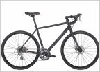 Should I get: Road bike or Cross bike?
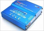 RC truck for newbies.
 HAM radio for beginners
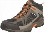 Mens Hiking Boots
 $100 --- what should i buy
 Looking at Drivers (Golf)
Android boating and hiking offline GPS app
Discussion in 'Sports, Hobbies & Interests' started by Sandman614, Jul 21, 2014.


