

-
Welcome to Tacoma World!
You are currently viewing as a guest! To get full-access, you need to register for a FREE account.
As a registered member, you’ll be able to:- Participate in all Tacoma discussion topics
- Communicate privately with other Tacoma owners from around the world
- Post your own photos in our Members Gallery
- Access all special features of the site
 Camping lightly- disposing of your waste out there or just making outdoors comfortable for some.
 Bakerla does Ouray 2013
 New to trail.driving
 Powertank Alternative
 Jerry Cans
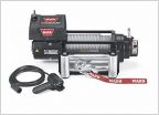 Which winch?
Pre-runner Friendly trails mear Tucson Az
Discussion in 'Off-Roading & Trails' started by kietdang28, Nov 10, 2015.
Page 2 of 2
Page 2 of 2


