

-
Welcome to Tacoma World!
You are currently viewing as a guest! To get full-access, you need to register for a FREE account.
As a registered member, you’ll be able to:- Participate in all Tacoma discussion topics
- Communicate privately with other Tacoma owners from around the world
- Post your own photos in our Members Gallery
- Access all special features of the site
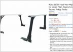 Modifying Rola Ladder Racks
 Not another TRD Pro suspension upgrade thread...
 Do they make it?
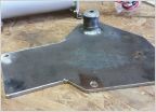 Air compressor advice
 TPMS question
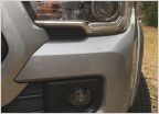 New fog lights installed
The maps suck
Discussion in '3rd Gen. Tacomas (2016-2023)' started by Chile Verde, Mar 13, 2017.
Page 5 of 7
Page 5 of 7


