

-
Welcome to Tacoma World!
You are currently viewing as a guest! To get full-access, you need to register for a FREE account.
As a registered member, you’ll be able to:- Participate in all Tacoma discussion topics
- Communicate privately with other Tacoma owners from around the world
- Post your own photos in our Members Gallery
- Access all special features of the site
 The Lunar Lander
 2001 DC Build and 2000 XC Tribute
 Synergy10's 02 Extra Cab Build
 Cbechtold's Long Travel IFS Crawler Tacoma Build and BS Thread
 The Life and Times of Lola
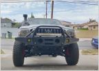 Daily Driver Build
AdventureTaco - turbodb's build and adventures
Discussion in '1st Gen. Builds (1995-2004)' started by turbodb, Apr 4, 2017.
Page 145 of 281
Page 145 of 281
Products Discussed in


