

-
Welcome to Tacoma World!
You are currently viewing as a guest! To get full-access, you need to register for a FREE account.
As a registered member, you’ll be able to:- Participate in all Tacoma discussion topics
- Communicate privately with other Tacoma owners from around the world
- Post your own photos in our Members Gallery
- Access all special features of the site
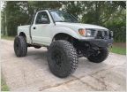 Allenfab's 95 Tacoma build
 FATS builds a Taco
 Looking for battery disconnect switch mounting options
 Crimson & Clover - Over and over and over and over....
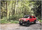 NWXPDTN - 04 TRD 4x4 XCab
 03 I Wish I Was Done With College "Build"
AdventureTaco - turbodb's build and adventures
Discussion in '1st Gen. Builds (1995-2004)' started by turbodb, Apr 4, 2017.
Page 186 of 281
Page 186 of 281
Products Discussed in


