

-
Welcome to Tacoma World!
You are currently viewing as a guest! To get full-access, you need to register for a FREE account.
As a registered member, you’ll be able to:- Participate in all Tacoma discussion topics
- Communicate privately with other Tacoma owners from around the world
- Post your own photos in our Members Gallery
- Access all special features of the site
 Daily Driver Build
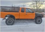 Truck of Joe
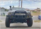
 Cbechtold's Long Travel IFS Crawler Tacoma Build and BS Thread
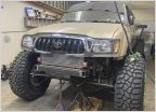 Ugly Gold 4 door Hoor SAS-LS
 My Big Can of Worms Build
 Shabuties DCSB (re)build
AdventureTaco - turbodb's build and adventures
Discussion in '1st Gen. Builds (1995-2004)' started by turbodb, Apr 4, 2017.
Page 217 of 280
Page 217 of 280
Products Discussed in


