

-
Welcome to Tacoma World!
You are currently viewing as a guest! To get full-access, you need to register for a FREE account.
As a registered member, you’ll be able to:- Participate in all Tacoma discussion topics
- Communicate privately with other Tacoma owners from around the world
- Post your own photos in our Members Gallery
- Access all special features of the site
 Burt, The Old Man With friends Daryl and Donna
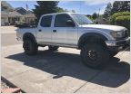 RDT415's 04 DCSB SR5 4x4 Build
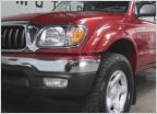 Crimson & Clover - Over and over and over and over....
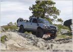 Oliver the Lunar Mist Ext Cab Build, dual cased and double locked
 Charlie's 95 KR to KY LT Taco
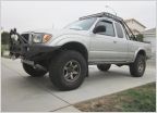 My 02 SR5 4WD Build - "T. Belle"
AdventureTaco - turbodb's build and adventures
Discussion in '1st Gen. Builds (1995-2004)' started by turbodb, Apr 4, 2017.
Page 225 of 281
Page 225 of 281
Products Discussed in


