

-
Welcome to Tacoma World!
You are currently viewing as a guest! To get full-access, you need to register for a FREE account.
As a registered member, you’ll be able to:- Participate in all Tacoma discussion topics
- Communicate privately with other Tacoma owners from around the world
- Post your own photos in our Members Gallery
- Access all special features of the site
 Tanya the Toyota Tacoma - Cattywampus '04 Ext Cab
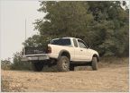 Allex95s Tacoma Build & Trips
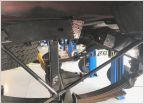 Mid Atlantic TACO build
 Kooks Mid Travel DC Build and BS Thread
 Djm228's maintenance thread
 First Gen IFS with Duals
AdventureTaco - turbodb's build and adventures
Discussion in '1st Gen. Builds (1995-2004)' started by turbodb, Apr 4, 2017.
Page 229 of 281
Page 229 of 281
Products Discussed in


