

-
Welcome to Tacoma World!
You are currently viewing as a guest! To get full-access, you need to register for a FREE account.
As a registered member, you’ll be able to:- Participate in all Tacoma discussion topics
- Communicate privately with other Tacoma owners from around the world
- Post your own photos in our Members Gallery
- Access all special features of the site
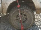 Reese farm jack vs. hi lift
 ****** DELETE *****
 Has anyone used the magellan on trails?
 Winch
Winch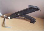 Changing a tire out on the trail
 Pooping while overlanding
Gaia Pro or ON-X Offroad- Why? Why not?
Discussion in 'Off-Roading & Trails' started by TacoPacific, Sep 3, 2023.
Page 3 of 3
Page 3 of 3


