

-
Welcome to Tacoma World!
You are currently viewing as a guest! To get full-access, you need to register for a FREE account.
As a registered member, you’ll be able to:- Participate in all Tacoma discussion topics
- Communicate privately with other Tacoma owners from around the world
- Post your own photos in our Members Gallery
- Access all special features of the site
 Stupid Cheap Front Wheel Bearings & Hubs
 Hidden spare key option
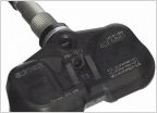 Who can advise regarding TPMS programming?
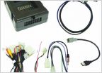 Clock Spring Gone Bad? - Check My Diagnosis
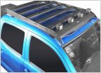 Kayak Rack Compatible with Hooke Roof Rack?
 Adding Nav/Sat. Radio
how do you navigate; cell phone?
Discussion in '2nd Gen. Tacomas (2005-2015)' started by TacoTuesday1, Apr 19, 2020.


