

-
Welcome to Tacoma World!
You are currently viewing as a guest! To get full-access, you need to register for a FREE account.
As a registered member, you’ll be able to:- Participate in all Tacoma discussion topics
- Communicate privately with other Tacoma owners from around the world
- Post your own photos in our Members Gallery
- Access all special features of the site
 Tail gate lock question
 2005 V6 4.0 6 speed clutch kit
 Lets talk carrier bearing part numbers
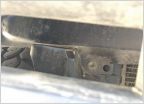 Core Support is Tearing Itself Apart
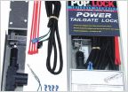
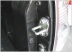 Pop Lock, locking tailgate... Anyone experiencing any problems?
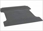 Bed mats and D-rings
What do you guys use for off-road navigation?
Discussion in '2nd Gen. Tacomas (2005-2015)' started by Krs1760, Mar 16, 2017.
Page 2 of 2
Page 2 of 2


