1. Welcome to Tacoma World!

    You are currently viewing as a guest! To get full-access, you need to register for a FREE account.

    As a registered member, you’ll be able to:
    • Participate in all Tacoma discussion topics
    • Communicate privately with other Tacoma owners from around the world
    • Post your own photos in our Members Gallery
    • Access all special features of the site
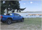
DE VI - The Pony Express Trip Report

Discussion in 'Trip Reports' started by Scott B., Jun 17, 2016.

  1. Jun 17, 2016 at 8:00 PM
    #1
    Scott B.

    Scott B. [OP] Well-Known Member

    Joined:
    Nov 11, 2014
    Member:
    #142118
    Messages:
    4,241
    Gender:
    Male
    First Name:
    Scott
    Georgia
    Vehicle:
    2015 ACLB SR5 4x4 Expo
    Another very successful Desert Expedition trip!

    5100 miles driven (500+ on dirt), 16 states passed through, 15 nights in the teardrop. Great company, great food, great trails - and snow! And let's not forget the metric ton of dust on everything!

    We kept a daily log and will be posting it one day at a time with pictures.

    Sit back, relax (and be patient) and enjoy.

    Here we go...
     
    buffedout and RogueTRD like this.
  2. Jun 17, 2016 at 8:04 PM
    #2
    Scott B.

    Scott B. [OP] Well-Known Member

    Joined:
    Nov 11, 2014
    Member:
    #142118
    Messages:
    4,241
    Gender:
    Male
    First Name:
    Scott
    Georgia
    Vehicle:
    2015 ACLB SR5 4x4 Expo
    Day One & Two - St. Joseph MO to Sydney, NB

    Our Pony Express exploration began in the great city of St. Joseph MO founded by Joseph Robidoux, 4th generation fur trader. In St. Joseph, we first admired the Pony Express monument and then strolled by war veteran memorials in the park.

    IMG_1.jpg

    IMG_2.jpg

    The Pony Express Museum at the original pony express stables was well attended and quite informative. The house where Jesse James was murdered was a short walk away. We interrupted our Pony Express exploration for lunch at Ground Round. The Patee Museum, home of the original Pony Express offices, offered a stroll through bygone times, including a carousel, an old steam engine, a grand ballroom visited by Abraham Lincoln, Mark Twain, and countless others, and a showcase of the Robidoux Hotel, which had been demolished in the 1970s.

    IMG_3.jpg

    IMG_4.jpg

    Last stop of the day was the Ferry boat monument along the Missouri River where Pony Express riders crossed to begin the 2000 mile westward ride.


    The next day we had a quick breakfast, closed camp, and headed west across the Missouri River into Kansas following the Pony Express route along KS 36.

    IMG_5.jpg

    IMG_6.jpg


    Stopped for a walk around the Hollenberg station outside of Hanover. Developed and operated by an innovative German settler to sell goods to westward bound emigrants and provide rest and provisions for Pony Express riders, the weathered six-room building constructed in 1858 still stands atop a hill overlooking flat campgrounds, farm fields, and stream beds. This building is in fact, one of the last original Pony Express Stations standing today.

    IMG_7.jpg

    Next stop, northward into Nebraska was the Rock Creek station where we mused through the museum and then walked the grounds finding a reconstructed cabin and post office amid the wagon trail ruts.

    IMG_8.jpg

    IMG_9.jpg

    IMG_10.jpg

    We piled back into the trucks to find present-day Dickey's Barbeque in Troy NE. Onward to Sidney we ran into a sudden storm that we later found out displayed 5 twisters visible outside of Cabela's home store. The rain pelted and we wondered if the wind would pick us up and throw us back into Kansas. After the storm subsided, we arrived safely at the Cabela's camp. Luckily we hit free-pie Monday at Perkins and brought pie slices back to camp to enjoy sometime in the next day or so.

    Total distance traversed was 525 miles in 10 hours drive time including Pony Express stops.
     
    buffedout and RogueTRD like this.
  3. Jun 17, 2016 at 8:13 PM
    #3
    Scott B.

    Scott B. [OP] Well-Known Member

    Joined:
    Nov 11, 2014
    Member:
    #142118
    Messages:
    4,241
    Gender:
    Male
    First Name:
    Scott
    Georgia
    Vehicle:
    2015 ACLB SR5 4x4 Expo
    The original Pony Express stables in St. Joseph

    PE1.jpg

    The house where Jessie James was shot (moved from its original location)

    PE2.jpg

    The monument, at the place in the river where the mail crossed by boat and was carried by horse to Sacramento, CA.

    PE3.jpg

    Another view of Hollenberg Station

    PE4.jpg

    Another view of Rock Creek Station

    PE5.jpg
     
    buffedout and RogueTRD like this.
  4. Jun 17, 2016 at 8:14 PM
    #4
    Scott B.

    Scott B. [OP] Well-Known Member

    Joined:
    Nov 11, 2014
    Member:
    #142118
    Messages:
    4,241
    Gender:
    Male
    First Name:
    Scott
    Georgia
    Vehicle:
    2015 ACLB SR5 4x4 Expo
    Day Three - I-80 Road Trip

    Cool rain showered us through the night. We are mightily thankful for our hard sided tent - teardrop- on such nights as we slept warm and dry. Upon awakening, we packed up and hit the highway westbound for Wyoming. First sighting of snow fence was at the Nebraska /Wyoming state line. Speed limit jumped to 80 mph so as long as the highway is clear of snow, you can really get down the road in good time. It wasn't too much later that we saw snow piled along the snow fences here in May! Sometime past Laramie weren't we surprised when seeing another teardrop-like trailer approach that it was our expedition buddy Martin and his wife returning home to Denver from a trek to Washington state. We pulled into Green River WY to grab some tacos not far from the visitor center we had stopped at 2 years prior on our Flaming Gorge trip. Continuing into Utah we made the pass through the mountains overlooking Salt Lake City. Once past Salt Lake City traffic we slipped around the southern tip of Salt Lake. The salt flats continued all the way west across the state to the Nevada state line. We made a quick stop at the Bonneville Salt Flats to fulfill one of Scott's dreams, seeing the track where speed records were set.

    D3-17.jpg

    D3-2.jpg

    Crossing into Nevada at West Wendover, we found the KOA campground where we joined up with Sib and Gary. We dined together at one of the many casinos and retired for the night expecting Frenchie's arrival by midnight.

    Total distance traversed 600 miles in 12 hours.
     
    buffedout and RogueTRD like this.
  5. Jun 18, 2016 at 6:59 PM
    #5
    Scott B.

    Scott B. [OP] Well-Known Member

    Joined:
    Nov 11, 2014
    Member:
    #142118
    Messages:
    4,241
    Gender:
    Male
    First Name:
    Scott
    Georgia
    Vehicle:
    2015 ACLB SR5 4x4 Expo
    No high-speed runs this day.

    Of course, a boat with a very shallow draft maybe.......

    bsf1.jpg

    bsf2.jpg
     
    buffedout and RogueTRD like this.
  6. Jun 21, 2016 at 4:07 PM
    #6
    Scott B.

    Scott B. [OP] Well-Known Member

    Joined:
    Nov 11, 2014
    Member:
    #142118
    Messages:
    4,241
    Gender:
    Male
    First Name:
    Scott
    Georgia
    Vehicle:
    2015 ACLB SR5 4x4 Expo
    Day 4 - Group convenes and off we go

    We arose early, counted heads to make sure all were present, grabbed breakfast at the local casino (only game in town), got provisions, and studied the maps.

    d4-1.jpg

    Agreeing on a path, we headed out westward bound on I-80 to Elko to get off paved roads. We turned north on 225 in Elko and then west onto the road to Swales mountain. Here the adventure began. Six vehicles, six gps's and not much agreement among them. The drive through mountains and valleys, around hills and through open pastures afforded us many views of Swales mountain but we never found the road up to the mountain itself. We did see several ranches few and far between. And the fields were in bloom!

    d4-2.jpg

    So there were lots of cows in the open range and they must not be used to seeing teardrops in their neck of the ranch because they always stopped to get a good look at us as we passed.

    d4-3.jpg

    After lunch, and note -- it's always hard to tear away from Frenchie's stories, as you can see how engrossed we all were -- but we did and headed onward to Swales mountain.

    d4-4.jpg

    Lucky for me, Scott got sleepy and after remarking he could use a nap, I offered to drive and was afforded the opportunity. My first trail driving on our expeditions and oh -what fun it was. Sure, it takes focused attention on path conditions, ruts, tire placement, 3 axles, gear shifting, keeping off the brake and being in the right gear, but I had the best instructor sitting at my side. After yet another choice in route and upon deciding to turn around, we happened upon the perfect campsite flat and roomy enough for us all. We called it quits for the day, set up camp, and settled in for some snacks, cranberry drinks and light-hearted conversation. Then came my favorite part of every day -- watching Scott prepare dinner which tonight would be grilled steaks and mushrooms with zucchini and onions, while sipping on Keith's cranberry juice and partaking in the storytelling.

    d4-5.jpg

    We retired after showers under a beautiful star lit sky. Camp was at 5700' altitude, we had traveled some 35 miles off road in 4.5 hours.
     
    buffedout and RogueTRD like this.
  7. Jun 21, 2016 at 4:09 PM
    #7
    Scott B.

    Scott B. [OP] Well-Known Member

    Joined:
    Nov 11, 2014
    Member:
    #142118
    Messages:
    4,241
    Gender:
    Male
    First Name:
    Scott
    Georgia
    Vehicle:
    2015 ACLB SR5 4x4 Expo
    Curious onlookers...

    d4-1.jpg

    The advantages of having a co-driver!

    d4-2.jpg
     
    buffedout and RogueTRD like this.
  8. Jun 22, 2016 at 5:32 PM
    #8
    Scott B.

    Scott B. [OP] Well-Known Member

    Joined:
    Nov 11, 2014
    Member:
    #142118
    Messages:
    4,241
    Gender:
    Male
    First Name:
    Scott
    Georgia
    Vehicle:
    2015 ACLB SR5 4x4 Expo
    Day 5 - Roads Not Maintained In Winter

    Cool morning bid us out of our teardrop to cook breakfast, pack up and find our way back to the bridge on the opposite side of Swales Mountain. Our route was sometimes elusive with even the 2-track path disappearing into the vegetation.

    d5-1.jpg

    Prettiest drive ever through fields of Indian paint brush, asters, and many others too numerous to name (especially since none of us knew the floral names) - purples, pinks, yellows, and whites. We finally came upon the bridge - our starting place yesterday- some 55 miles looping around Swales mountain.

    d5-2.jpg

    d5-3.jpg

    We made our way back to NV 225 and headed northbound for Dinner Station. The turn of the century house had suffered fire damage and was restored by its current day owners. Around the turn of last century, 1900, upwards of 75 people per day frequented the place for a meal and a rest for their horses. Today the beautiful stone building is occupied and is a working ranch.

    d5-4.jpg

    Next destination was Cornocopia mine but our trail ended in a locked gate so we headed to Humboldt National Forest to find a camp spot for the night. Climbing through the mountains on a path that the Benchmark map book cautioned "road not maintained in winter" we encountered snow and then happened upon an impassable snowbank covering the road.

    d5-5.jpg

    d5-6.jpg

    Luckily an alternate path with a muddy slide down a steep hill, across a stream and back up a steep climb and we were on the other side of the snow bank.

    d5-7.jpg

    Rounding the next bend we came upon yet another snow drift, this one flatter and shallower than the previous. We pulled out the shovels and dug a trench for the right side tire path to keep the trucks from sliding down the canyon while crossing the snow drift.

    d5-8.jpg

    Gary was the first one to cross and while we lined up to follow, he radioed back that at the next bend, he had come upon the biggest snow drift yet which would not be passable, not in the winter, not even in June. The "roads not maintained in winter" warning which we didn't think applied to us June travelers came into play.

    d5-9.jpg

    So, after getting the trailer turned around, we made our way back down the steep descent, over the stream, and up the muddy slope with a little help from Frenchie and a trusty tow rope (and this is really important -- if one can remember -- low range can be extremely helpful in such places!).

    Retracing our path to a lower elevation, we found camp at an embankment near a rushing stream with snow at a safe distance away. Sipping on cranberry drinks (yes, again!), we enjoyed a hot meal of black beans, chicken and rice. The evening was short as night was upon us. Camp was at 7200', and we had traversed 45 miles.

    d5-10.jpg
     
    buffedout and RogueTRD like this.
  9. Jun 22, 2016 at 5:51 PM
    #9
    Scott B.

    Scott B. [OP] Well-Known Member

    Joined:
    Nov 11, 2014
    Member:
    #142118
    Messages:
    4,241
    Gender:
    Male
    First Name:
    Scott
    Georgia
    Vehicle:
    2015 ACLB SR5 4x4 Expo
    A view from the bridge

    d5-1.jpg

    Wide open spaces...

    d5-2.jpg

    Remember, this is June in the desert!

    d5-3.jpg

    The bypass

    d5-4.jpg
     
    buffedout and RogueTRD like this.
  10. Jun 24, 2016 at 9:13 AM
    #10
    RogueTRD

    RogueTRD Learn to swim...

    Joined:
    Aug 11, 2011
    Member:
    #61546
    Messages:
    2,770
    Gender:
    Male
    First Name:
    Cade
    So. Oregon
    Vehicle:
    Supercharged '14 Pyrite Mica DCSB 4x4 TRD OR
    Stacked spacer lift, 22x12 wheels with stretched 33's, tow mirrors, bull nuts.
    Looks like a cool trip, thanks for the pics and write up.
     
  11. Jun 24, 2016 at 12:38 PM
    #11
    Scott B.

    Scott B. [OP] Well-Known Member

    Joined:
    Nov 11, 2014
    Member:
    #142118
    Messages:
    4,241
    Gender:
    Male
    First Name:
    Scott
    Georgia
    Vehicle:
    2015 ACLB SR5 4x4 Expo
    Stay tuned - 6 more days of pictures to go!
     
    RogueTRD[QUOTED] likes this.
  12. Jul 4, 2016 at 5:25 PM
    #12
    Scott B.

    Scott B. [OP] Well-Known Member

    Joined:
    Nov 11, 2014
    Member:
    #142118
    Messages:
    4,241
    Gender:
    Male
    First Name:
    Scott
    Georgia
    Vehicle:
    2015 ACLB SR5 4x4 Expo
    Day 6 - Down in the valley...

    Fresh, hot-off-the-griddle blueberry pancakes for all started our day. The air was refreshingly cool with the view of nearby snowbanks. After calibrating with our maps...

    d6-1.jpg

    We made our way out of Humboldt National forest, through Jack Creek, south on NV 226 and back off-road onto 736 heading south for Austin NV (not TX) eventually. We passed through open ranges and coaxed the numerous cattle to free up road space so we could pass. Luckily we had the cow whisperer with us.

    d6-2.jpg

    d6-3.jpg

    We happened upon one cowboy working a herd and although he was hard at work, he made for a picturesque site. Look closely and you'll spot him just below the mountain range in the left side of this shot.

    d6-4.jpg

    The ranches, spread few and far between, looked spectacular and every now and then our journey on county roads took us right into the innermost workings of some of them.

    d6-5.jpg

    At mid day we stopped in Carlin for fuel, provisions, and a few tacos at the local Mexican restaurant. All refreshed, we headed south on NV 278 out of town back onto dirt at Palisade. Coming across a bridge built in 1902, we got out to inspect the condition of the lumber which looked to be original from last century. We could actually feel the boards give way under our feet as we walked across it.

    d6-7.jpg

    Deciding the bridge would hold every last one of us, we crossed and continued southbound into Frenchie Flat for a long straight dusty ride through the valley. Frenchie Flat felt like coming home so we found camp in Cottonwood canyon. Talk about inspirational -- nestled next to a mountain, with a running brook nearby, overlooking a valley, and mountains beyond, Frenchie treated us all to beef and bean burritos, Keith supplied the juice/spirits for the evening and we got to visit under the star-filled sky.

    d6-8.jpg

    d6-9.jpg

    d6-10.jpg

    d6-11.jpg

    As if that were not enough, we topped off the day with warm <private> showers (in Frenchie's shower tent) washing away the day's dust and sweat leaving each of us refreshingly cool. I'm not even going to mention the pesky mosquitos, nope, not me, not a word. There was talk of a UFO siting but nothing definitive. Camp was at 5100' 200 miles traversed.
     
    buffedout likes this.
  13. Jul 4, 2016 at 5:32 PM
    #13
    Scott B.

    Scott B. [OP] Well-Known Member

    Joined:
    Nov 11, 2014
    Member:
    #142118
    Messages:
    4,241
    Gender:
    Male
    First Name:
    Scott
    Georgia
    Vehicle:
    2015 ACLB SR5 4x4 Expo
    Early morning at camp

    d6-1.jpg

    More wide open spaces

    d6-2.jpg

    The turnoff to Jack Creek

    d6-3.jpg

    Fences...

    d6-4.jpg

    Barns...

    d6-5.jpg

    Can't forget trains...

    d6-6.jpg

    And the bridge...

    d6-7.jpg

    d6-8.jpg
     
    buffedout likes this.
  14. Jul 4, 2016 at 5:41 PM
    #14
    Scott B.

    Scott B. [OP] Well-Known Member

    Joined:
    Nov 11, 2014
    Member:
    #142118
    Messages:
    4,241
    Gender:
    Male
    First Name:
    Scott
    Georgia
    Vehicle:
    2015 ACLB SR5 4x4 Expo
    Day 7 - Gold Rush

    We awoke to an already-warm sun, had scrambled eggs for breakfast, packed up, and headed back into Crescent Valley in search of Gold Acres mine. What we found instead was a large operational mine called Cortez. The gate guard gave us instructions for routing around the Cortez mine to get to Gold Acres mine but even his instructions didn't seem to lead to the ghost mine.

    d7-1.jpg

    So we headed west through a couple of horse ranches in Redrock Canyon out to NV 306. Southbound on NV 306 took us to Austin NV and Nevada Route 50, dubbed the loneliest road in America. We got fuel and found a shade tree to stop for a lunch break. The dirt road past the Chevron station took us up to Stokes Castle, a three story stone structure fashioned after a castle in Rome.

    d7-2.jpg

    d7-3.jpg

    After the castle exploration, we headed west out of town some 5 miles to view a Pony Express Station and although the site was well marked we couldn't even find a rubble pile. Heading back towards Austin, we turned south onto 002 - not much more than a bike trail - heading into Humboldt Toiyabe National Forest. Scott got out his bow saw to widen the track for passage in a couple of spots.

    d7-4.jpg

    We turned east onto 125 and climbed to 8560' at which point we came upon uh-oh -- a snow bank! This one, unlike our previous encounters, had a nice berm to make it passable.

    d7-5.jpg

    d7-6.jpg

    We went across the snow bank and found a plateau which we called camp. The open area overlooked a tiered mine and mountain peaks. The camp pizza was delicious and the skillet-fresh brownies afterwards were a sweet reward as we sat around Gary's welcoming campfire and viewed the night sky.

    d7-7.jpg

    Here we all are... well, except the photographer, of course.

    d7-8.jpg

    We anticipated a cold night as we looked upon snow covered mountains. Our day was a 140 mile run.
     
    buffedout likes this.
  15. Jul 4, 2016 at 5:51 PM
    #15
    Scott B.

    Scott B. [OP] Well-Known Member

    Joined:
    Nov 11, 2014
    Member:
    #142118
    Messages:
    4,241
    Gender:
    Male
    First Name:
    Scott
    Georgia
    Vehicle:
    2015 ACLB SR5 4x4 Expo
    More wide open spaces...

    d7-1.jpg

    A current resident of Stoke's Castle

    d7-2.jpg

    d7-3.jpg

    The bike trail

    d7-4.jpg

    More snow!

    d7-5.jpg

    View from the top

    d7-6.jpg

    d7-7.jpg

    d7-9.jpg

    First time the truck is in snow!

    d7-8.jpg

    Dinner and dessert - fresh baked at 9500'

    d7-10.jpg

    d7-11.jpg
     
    buffedout likes this.
  16. Jul 5, 2016 at 7:11 PM
    #16
    Scott B.

    Scott B. [OP] Well-Known Member

    Joined:
    Nov 11, 2014
    Member:
    #142118
    Messages:
    4,241
    Gender:
    Male
    First Name:
    Scott
    Georgia
    Vehicle:
    2015 ACLB SR5 4x4 Expo
    Day 8 - Spelunking (or for our British friends - Potholing)

    The night was not nearly as cold as we had anticipated. Started our day with a breakfast of eggs, sausage, onion, and tortilla strips, all scrambled together. Love one-pan cooking, especially when Scott is the cook! We continued down past the open mine into a canyon offering fantastic displays of rock cliffs.

    d8-1.jpg

    We happened upon a partially standing rock house off to the side of the path. Here you can catch Frenchie frolicking.

    d8-2.jpg

    Coming out of the mountains, Big Smokey Valley stretched before us. We turned north on NV 376 to find Pete Summit's road heading northeast back into the Humboldt National Forest. At Spencer's hot spring we shed our footwear and soaked our feet in the warm water while Keith slipped down into the basin for a full soak. Someone please post a photo of that!

    When we reached some shade trees we stopped for a lunch break. Listening to the wind howl through the canyons belied the hot weather and held promise of cooler temps to come. We headed south east on 001 to Toquima Cave where we hiked a quarter mile to the cave mouth to view the ancient Shoshone paintings.

    d8-3.jpg

    d8-4.jpg

    d8-5.jpg

    d8-6.jpg

    d8-7.jpg

    Coming down the mountain we entered Monitor ranch -- literally we drove through the ranch houses and scattered buildings -- and turned west onto 138 to find a camp spot for the night . We climbed to 9550' altitude and found a site in among some sheltering trees and as we listened to howling winds, we now had to wonder if we were in for a snowy night. Dinner of zucchini and onion with ground beef settled us down for a evening campfire to warm us from the brisk winds. Camp was in Stoneberger basin and we had traversed 50 miles.
     
    buffedout likes this.
  17. Jul 5, 2016 at 7:16 PM
    #17
    Scott B.

    Scott B. [OP] Well-Known Member

    Joined:
    Nov 11, 2014
    Member:
    #142118
    Messages:
    4,241
    Gender:
    Male
    First Name:
    Scott
    Georgia
    Vehicle:
    2015 ACLB SR5 4x4 Expo
    The view from camp

    d8-1.jpg

    Tailings from a gold mine

    d8-2.jpg

    Fences...

    d8-2a.jpg

    d8-3.jpg

    Beautiful scenery

    d8-4.jpg

    d8-5.jpg

    Long abandoned residence

    d8-6.jpg

    View from Toquima Cave

    d8-7.jpg
     
    buffedout likes this.
  18. Jul 25, 2016 at 7:01 PM
    #18
    Scott B.

    Scott B. [OP] Well-Known Member

    Joined:
    Nov 11, 2014
    Member:
    #142118
    Messages:
    4,241
    Gender:
    Male
    First Name:
    Scott
    Georgia
    Vehicle:
    2015 ACLB SR5 4x4 Expo
    Day 9 - Snow day - yes, in June

    No snow, no rain, the night was beautiful. We started our day with oatmeal and bananas, packed up camp, and headed further west on 138 to see if it really was passable. We made it as far as the junction just passed 348A at which point the 15' snow drift had us deciding to turn around and retrace our steps east back to Monitor Valley.

    d9-1.jpg

    d9-2.jpg

    Several steep climbs, a few water streams crossing the path, and cow herds to greet us in passing and we were back on the east side of the mountain range.

    d9-3.jpg

    d9-4.jpg

    d9-5.jpg

    We found a shady spot for lunch before dropping into the valley and turning south heading toward Northumbelrand Gold Mine. We found 023 and turned west toward the mine. The mine access road was gated and locked so we headed up the mountain and were surprised by the view from atop. The open pit mine stretched on far and wide. The roadway was cut wide for heavy mining equipment.

    d9-6.jpg

    On the ride down and out west towards Smokey Valley we hunted a good flat protected but open camp site and passed through rocky canyons out into the valley. Knowing we wouldn't find camp in the valley we retraced our path back up 5 miles on Northumberland to camp just west of the mine.

    d9-7.jpg

    Black bean dip and chips to complement the juice drinks were enjoyed by all the travel-weary campers while we grilled kielbasa and onions for dinner.

    d9-8.jpg

    d9-9.jpg


    Camp was at 7400' elevation and we had traveled 60 miles.
     
  19. Jul 25, 2016 at 7:06 PM
    #19
    Scott B.

    Scott B. [OP] Well-Known Member

    Joined:
    Nov 11, 2014
    Member:
    #142118
    Messages:
    4,241
    Gender:
    Male
    First Name:
    Scott
    Georgia
    Vehicle:
    2015 ACLB SR5 4x4 Expo
    Our nice, sheltered camp at 7400'

    d9-1.jpg

    View from camp

    d9-2.jpg

    I'm sensing a theme here...

    d9-3.jpg

    I almost stepped on this guy!

    d9-4.jpg

    A very large, working gold mine

    d9-5.jpg

    More spectacular scenery

    d9-6.jpg
     
  20. Jul 25, 2016 at 7:16 PM
    #20
    Scott B.

    Scott B. [OP] Well-Known Member

    Joined:
    Nov 11, 2014
    Member:
    #142118
    Messages:
    4,241
    Gender:
    Male
    First Name:
    Scott
    Georgia
    Vehicle:
    2015 ACLB SR5 4x4 Expo
    Day 10 - Finally found a ghost town - non-deserted!

    Banana pancakes for breakfast and conversation around the circle to start our day.

    d10-1.jpg

    d10-2.jpg

    We headed west out to the Smokey Valley to find a fuel stop on 376 where Sib would turn south and head for home while we headed back east to cut through the mountains again finding our way to the Great Basin National Park. Well, that was the plan anyway. Our GPSs took us to Manhattan for fuel. The skyline was in marked contrast to Manhattan Island of NY.

    d10-3.jpg

    Manhattan was without fuel proving once again that one can't rely solely on GPS information (...but it said so on the Internet). We retraced our path out of Manhattan and followed Sib's path heading south on 376 into Tonopah for fuel, provisions, and a Mexican meal at Los Marquez. Leaving Tonopah we headed back north on 376 a short ways turning northeast to Belmont. Belmont was a booming town of 2000 inhabitants during the mining boon. Many structures still stand including an impressive courthouse.

    d10-4.jpg

    d10-5.jpg

    The salon was open as there are permanent residents yet today. While the guys studied the intricacies of the road grader from the 1800s I meandered around town looking for the gift shop.

    d10-6.jpg

    d10-7.jpg

    d10-8.jpg

    I noticed upon finding this wagon tucked beside one of the buildings that the town-dwellers really enjoyed their cranberry juice too.

    d10-9.jpg

    I noticed upon finding this wagon tucked beside one of the buildings that the town-dwellers really enjoyed their cranberry juice too.

    d10-9a.jpg

    Then it was northward to Pine Creek Campground. The campground was overgrown so we picked a flat open spot near the trailhead and settled in for evening talk. After munching on Frenchie's Chicago mix popcorn, we played the cherry pit game which of course is seeing how far one could spit a cherry pit over another campers' head. Dinner of hot dogs, a warm shower and we were ready for star gazing. Camped at 7500', traversed 190 miles.
     

Products Discussed in

To Top