

-
Welcome to Tacoma World!
You are currently viewing as a guest! To get full-access, you need to register for a FREE account.
As a registered member, you’ll be able to:- Participate in all Tacoma discussion topics
- Communicate privately with other Tacoma owners from around the world
- Post your own photos in our Members Gallery
- Access all special features of the site
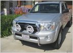 Which lights?
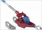 Hand winch instead of power winch?
 Does the Hi-Lift Bumper Lift work with 2nd Gen?
 Options to level Tacoma for camping
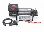 Which winch?
 First time for everything, literately.
Off road gps set up
Discussion in 'Off-Roading & Trails' started by lodi781, Feb 4, 2020.
Page 1 of 2
Page 1 of 2


