

-
Welcome to Tacoma World!
You are currently viewing as a guest! To get full-access, you need to register for a FREE account.
As a registered member, you’ll be able to:- Participate in all Tacoma discussion topics
- Communicate privately with other Tacoma owners from around the world
- Post your own photos in our Members Gallery
- Access all special features of the site
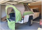 I fixed the bed tent that was free
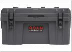 Hard case for roof rack storage - Pelican alternatives?
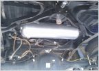 OBA
OBA ****** DELETE *****
 Air compressor
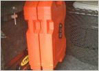 Jerry Cans
What Navigation Device do you use?
Discussion in 'Off-Roading & Trails' started by MyWyfsRnnr, Jun 25, 2019.
Page 1 of 2
Page 1 of 2


